


The Cave Mine District is located approximately two miles north of the Lincoln District. The broad distribution of old mines and workings in this area suggest that mineralization is related to a much larger hydrothermal system, perhaps a separate porphyry system, buried beneath shallow alluvium in the valley to the west.
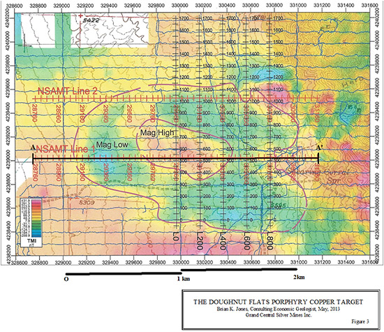
GCSM’s magnetic data from the valley west of the Cave Mine reveals a large “doughnut” anomaly, measuring 1.8 kilometers x 1.2 kilometers (figure 3). "Porphyry copper deposits often, but not always, appear as magnetic highs, with alteration halos usually manifested as annular (doughnut-shaped) or open-ring peripheral magnetic lows," Berger and others (2008).
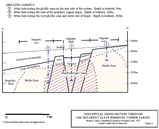
A conceptual cross-section through the target is shown in figure 4. The target is near surface, has not been drilled and may be open-pit mineable.
Zonge (2010) Engineering conducted NSAMT, Gradient IP and CRIP geophysical surveys in and around the area of the magnetic anomaly. They conclude, In the zone defined by the Gradient Grid, evidence of weak IP sources is identified. There is evidence of skarn mineralization in the vicinity with evidence of mineable mineralization at Cave Mine. Weak IP sources suggest that if sulfide mineralization is present, within the Gradient Grid and Cave Mine areas tested it is iron poor. They also noted that Gradient IP values are extremely low over the entire Gradient grid.
Joe Wilkins (2009), page 2 notes, The IP data are a measure of polarizable minerals in the subsurface, generally sulfides. In a "standard" porphyry copper deposit, a rather strong response is present; 5-10 times background. At the Cave Mine Project the response is weak, only about 2-3 times background. As shown on both dipole-dipole lines and to a lesser extent on the gradient array, a consistent +10 mrad response is present. This weak response suggests that the sulfides are present but are probably partially oxidized. The oxidation scenario is substantiated by the numerous mine dumps (that) have extensive iron oxides which replaced sulfide minerals, actual sulfides are relatively rare.
Windels (2010), page 18 says, The results from the earlier 2009 Gradient Array IP survey over the "Copper Porphyry Magnetic Doughnut Anomaly" (Doughnut Flats) were limited to 150-200 meter depth, due to a conductive zone on the south end of the grid.
NSAMT cross-sections through the Doughnut Flats target show zones of highly conductive overburden overlying largely resistive bedrock. These sections suggest that the depth to bedrock in the target ranges from about 50m at the east edge of the anomaly to 400m on the west edge.
Topographic maps show a distinct circular feature or ring structure about a mile across in and around the Cave Mine deposits. It is possible that the ring structure is a collapse feature associated with venting of hydrothermal solutions beneath the carbonate-hosted, lead-zinc-silver fissures. The Cave Mine mineralization is rootless, cut by the low-angle Cave Canyon Fault. The area of the ring structures is roughly equal to the area of the Doughnut Flats magnetic anomaly. This is an interesting coincidence and it’s possible that the two are the upper and lower parts of the same system, offset by post-mineral movement along the Cave Canyon Fault.
[ Top ]